
I have to admit, when I sit down to write about space technology or satellite data, I usually brace myself for heavy scientific jargon, complex orbital mechanics, and serious climate reports. But every now and then, I stumble across a project that just makes me smile like a kid. NASA recently brought back something brilliant, and I spent way too much time this morning playing with it instead of drinking my coffee.
Imagine taking the sprawling, chaotic beauty of Earth—its rivers, glaciers, deserts, and forests—and turning it into a personal typewriter. That is exactly what NASA’s “Your Name in Landsat” project does.
When the Kennedy Space Center recently shared this tool again, their pitch was perfect: “This planet can literally spell your name.” And honestly? They weren’t exaggerating. I immediately tried typing out a few words, and seeing standard letters replaced by satellite imagery of Earth’s natural wonders completely blew my mind.
Let me take you through what this tool actually is, the incredible 50-year-old technology behind it, and why I think this is one of the coolest ways to connect with our home planet.
What Exactly is the “Your Name in Landsat” Tool?
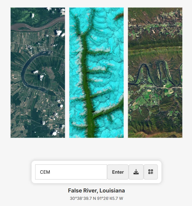
Originally launched as part of the “Camp Landsat” virtual event, this interactive web tool lets you type any word or name into a search bar. The system then generates that exact word using real satellite images of Earth’s surface.
Instead of a standard font, your letters are made of:
- Curving rivers that perfectly form an “S” or a “C”.
- Mountain ridges and valleys casting shadows that look just like a “V”.
- Agricultural fields carved into geometric shapes that mimic an “E”.
- Coastal lines and glaciers that naturally curve into an “O”.
It’s basically the ultimate cosmic typography. The tool taps into an absolutely massive archive of images collected over decades, scanning the globe to find natural topography that perfectly mimics the English alphabet.
The Science Behind the Art: A 50-Year Legacy
To really appreciate how cool this is, we have to talk about the unsung hero of space observation: the Landsat program.
Jointly managed by NASA and the United States Geological Survey (USGS), the Landsat satellites aren’t new. In fact, they have been quietly watching over us since 1972. For over half a century, these incredible machines have been orbiting Earth, taking continuous snapshots of its surface.
But these aren’t just regular camera phones strapped to a rocket. I was fascinated to learn about how they actually “see” the planet. Landsat uses advanced sensors to capture light far beyond what human eyes can process.
Here is what makes the imagery so visually striking:
- Infrared and Thermal Bands: Landsat sensors capture near-infrared and shortwave-infrared light.
- False-Color Imagery: When scientists process this invisible data into colors we can see, the results look like modern art.
- Stunning Contrasts: Deep, blood-red deserts, almost neon-green vegetation patches, and razor-sharp, icy blue river bends pop out against the landscape.
It’s this specific processing that makes the “letters” stand out so clearly. You aren’t just looking at a brown and green map; you are looking at Earth’s temperature, vegetation health, and mineral composition turned into a vibrant canvas.
Finding the Hidden Letters in Mother Nature
Creating an entire alphabet out of random planetary geology is no small feat. While researching this, I realized just how much effort went into hunting down these specific formations.
Some letters are surprisingly common in nature. For instance, the system has five different options for a capital “A”. One of my absolute favorites is an “A” formed entirely by the lush, dark green vegetation surrounding Lake Mjøsa in Norway. It’s sharp, distinct, and incredibly beautiful.
However, some lowercase letters are incredibly rare. Mother Nature doesn’t naturally draw a lot of tiny, complex loops. The lowercase “g” was famously difficult to track down. Currently, there is only one example in the entire database: a muddy, highly intricate river bend located deep within the Amazonas region of Brazil.
It makes you wonder—how many other secret messages are hidden in the mountains and rivers of the world, just waiting for the right satellite pass to be discovered?
Beyond the Alphabet: Why Landsat Actually Matters
As much fun as it is to write our names with rivers and mountains, I think it’s crucial to remember why Landsat is up there in the first place. The artistic alphabet is just a happy accident; the real mission is planetary survival.
Landsat is arguably the most important tool we have for tracking how human activity and climate change are altering the globe. Because the archive stretches back over 50 years, it provides an undeniable, visual timeline of our impact.
Here are a few things Landsat actively monitors:
- Urban Sprawl: The satellites have documented the explosive growth of cities. For example, you can watch a time-lapse of Las Vegas doubling in size over the last few decades, swallowing up the surrounding desert.
- Deforestation: The stark, geometric scars of logging in the Amazon rainforest are tracked in real-time, helping authorities combat illegal operations.
- Glacial Retreat: Watching massive ice sheets shrink year by year in the Landsat archives is a sobering reminder of global warming.
- Agriculture and Drought: By monitoring the infrared signatures of crops, scientists can tell if vegetation is healthy or suffering from drought, which is vital for global food security.
The Power of Making Space Accessible
So, why did NASA bother making a fun little name-generator tool out of such serious scientific data?
If you ask me, it’s all about connection. Space and satellite data can feel very abstract. Reading a report that says “urban footprints have expanded by 20%” doesn’t hit home for everyone. But when you log onto a website and realize that a piece of a Brazilian river forms the same letter you use to spell your own name, it creates an immediate, personal link between you and the planet.
It transforms Earth from a giant, incomprehensible rock into an intimate, shared home. It reminds us that we are part of this massive, interconnected system. Science shouldn’t just live in academic papers; it should be interactive, aesthetic, and sometimes, just plain fun.
If you haven’t tried it yet, I highly recommend taking a few minutes out of your day to spell out your name. Play around with it. Zoom in on the letters and see which country your initials come from. It’s a completely free tool, and it’s a brilliant way to explore the aesthetic face of science.
I spent ages looking at the different river formations that make up my letters. It got me thinking about how dynamic and constantly changing our planet really is.
I’m curious—what did your name look like? Which natural formation made up your favorite letter, and where in the world was it located? Let me know below!